This lists the map files created for Empire Deluxe Combined Edition. All files posted here are also available through the in-game Map Downloads. Please read through any special instructions before using these maps. Some of the maps below are based on scenarios and can reveal spoilers if played. It may be possible to port these files to other game versions, although I haven’t tried.
Files created with a map script should be placed in the “[AppData]\EmpireDeluxe\maps\” directory and need to be loaded during the map/scenario setup phase or viewed through the map editor.
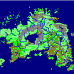
Adomaxia
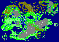
Adomaxia is the setting of the upcoming 2022 Empire Deluxe Tournament and is available on this website for early download. The map traces its origins to the art created by created by NadrojDranreb and posted to Wondercraft in 2019. Per the original author, it is inspired by cultures from Canada, Scandinavia, and Baltic geographies. The map features 24 countries that take place in the northern hemisphere of the world originally created for Leonia.
Some creative liberties were taken in order to make the map competition ready in Empire Deluxe, including expansion of the various regions and the inclusion of resources in key terrain spots from the map. The map features a single large continent separated by a dense swampland with sparse northern island covered in snow. There are also two archipelagos which are quite lucrative if you can capture them. In play tests, most combat takes place across the vertical axis, but the map has full wrapping enabled.
Download FileLast Modified: 2022/12/13 | Version 1.0.0 | Link to Full Description |
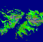
Western Anima, Beyond Fantasy
Western Anima is a continent of Gaia, the world of Anima : Beyond Fantasy. The continent has wide open plains seperated by high peaks and mountain ranges that split it into multiple regions. The map includes 9 Region Centers with over 200 cities. The map uses vertical and horizontal wrapping to create a more competitive scenario.
Download FileLast Modified: 2021/12/09 | Version 1.0.0 | Link to Full Description |
Map of Afghanistan (2021)
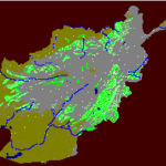
Afghanistan is a landlocked country at the crossroads of Central and South Asia. It is bordered by Pakistan to the east and south, Iran to the west, Turkmenistan and Uzbekistan to the north, and Tajikistan and China to the northeast. Occupying 652,864 square kilometers (252,072 sq mi), the country is predominately mountainous with plains in the north and southwest. It is inhabited by 31.4 million people as of 2020, composed mostly of ethnic Pashtuns, Tajiks, Hazaras, and Uzbeks. Kabul serves as its capital and largest city.
For almost 20 years, Afghanistan was a continuous battleground for armies and insurgents. In 2020, a new chapter emerged as the Doha Agreement promised to re-shape the future of the conflict. This map represents the state of Afghanistan as it appears in March 1, 2021.
Download FileLast Modified: 2021/09/01 | Version 1.0.0 | Link to Full Description |
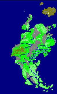
Island of Harn Map
Harn is a rough, hazy, forested isle roughly 100 miles off the northwest coast of the continent of Lythia, on the edge of the Haonic Ocean. Compared to other regions of northwest Lythia, Harn is a wild, barbaric land, where pockets of civilization are surrounded by large tracts of wilderness.
Harn’s center is dominated by Lake Benath, a freshwater lake drained by the Thard River. The longest river is the Kald (375 miles), which drains the eastern interior. Much of Harn is hilly. There are four mountain ranges of note: the Felshas, running north-south in central Harn and boasting the island’s highest peaks; the Rayeshas, running east-west along the top of Lake Benath; the Sorkins, running northsouth along the east coast; and the Jahls in the far north.
Download FileLast Modified: 2020/12/07 | Version 1.0.1 | Link to Full Description | Latest Version Update
Falkland Islands
The Falkland Islands is an archipelago in the South Atlantic Ocean on the Patagonian Shelf. The archipelago, with an area of 4,700 square miles (12,000 square kilometres), comprises East Falkland, West Falkland and 776 smaller islands. As a British overseas territory, the Falklands have internal self-governance, and the United Kingdom takes responsibility for their defence and foreign affairs. In April 1982, Argentine forces temporarily occupied the islands. British administration was restored two months later at the end of the Falklands War. The Falkland Islands’ capital is Stanley on East Falkland.
- This map is free of any unintended spoilers for the Falklands War (1982) scenario.
- Efficiency ratings are based on population. Most cities start with efficiency under 50% and is therefor difficult to play without modification.
- Optional: The Falklands AI Script has been added for this map. See AI Scripts section for more details.
Last Modified: 2019/01/01 | Version 1.0.0 | Link to Full Description |